Ancient Egypt(P4) The Nile River and the Geography of Upper and Lower Egypt
Hey there! Welcome back to The Historical Musings. Today we will be getting into a slightly confusing part of ancient Egypt so if you don't understand something read it thoroughly again and if you still don't understand, just comment and I'll make sure to reply. Our topics of the day will be the Nile River and the geography of Upper and Lower Egypt. With that being said let's get started!
Geography of the Nile Delta
The Nile river stretches through many parts of Africa and right through Egypt. It starts from the mountains in the south to the Mediterranean Sea in the north. However, before it reaches the Mediterranean, it splits into many little rivers that then run into the Sea. These little rivers together, shape an upside-down triangle. In Greek, the letter delta is also shaped like a triangle, so this segment of the river became known as the Nile Delta(the name is in Greek because it was a Greek historian who first defined that part of the Nile).
Flooding of the Nile
Throughout the rainy seasons, the Nile would flood every year. The rain would fall on the mountains to the south where the Nile river starts, pour into the river, then run down into the Delta. There was so much water that came down the Nile that it’s banks and farmland all overflowed! The wettest part of the river would be the Delta, and it would be completely submerged in water during the rainy seasons. Although it would appear that the overflowing of the Nile would be a disaster, for the ancient Egyptians it really wasn’t. Why? Well, when the water came up out of the river it would also pull up rich dirt that would sit along the edges of the river when the water receded. This dirt is called silt. The farmers who would live a bit away from the river(so their houses would not be flooded)would then come and plant their crops on the nutrient-filled silt.
Geography of Upper and Lower Egypt
In Egypt’s early history two tribes lived along the Nile. The tribe of Egyptians in the Nile Delta on the northern part of the river were called the “Lower Egyptians”. The tribe that lived on the more straight part of the river down south were called the “Upper Egyptians”. Now, I know what you must be thinking, on a map, the Nile Delta was up north and the straight way was down south so the tribe on the Nile Delta should be Upper Egypt and the tribe on the straight part should be Lower Egypt. However, that's not how the Egyptians saw the world. This is because the Nile river began flowing from the mountains to the south, down to the Delta in the North. Their whole lives were based upon the Nile. In the Egyptians eyes, the southern part of their country was up the river and the northern part was down the river. Here is a good map that shows this:
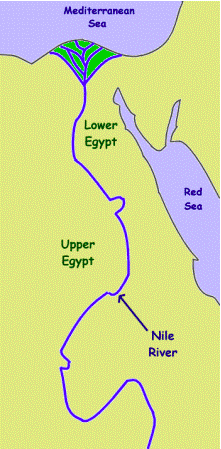
Image from Ducksters "Ancient Egypt Geography and the Nile River"
As you see in this picture, Lower Egypt is going up the river and Upper Egypt is going down.
I hope you found this post interesting as I went into more depth when talking about the Nile river than I previously did a few posts ago. I also hope you found it interesting to learn about this brand new topic we are getting into; Upper and Lower Egypt. We will be learning more about that in the next post. Be sure to follow to get notified when I do publish my next post. Like I said in the beginning if you have any questions at all, please be sure to comment. That's all I have for you today. Once again, I hope you enjoyed and I'll see you on the next post!
-The History Buff


Love it! Thanks
ReplyDelete